
Back to the library
Dataset
UCDP Georeferenced Event Dataset v26.1
Public ID
ADG-DAT-2026-002
Version
observatory/2026-09-08
Licence
CC-BY-4.0
1989-01-01 — 2025-12-31Period
Regional — West AfricaCoverage
QuantitativeCategory
OpenAccess
68 words · about a minute
Your browser cannot read text aloud. The written text is above.
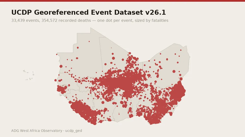
UCDP Georeferenced Event Dataset v26.1. Collected from Uppsala Conflict Data Program (academic) on a annual cadence. 33,439 records spanning 1989-01-01 to 2025-12-31, covering NGA, MLI, BFA, SLE, NER, LBR, CIV, SEN, TGO, GIN, BEN, GHA, MRT, GNB, GMB. Evidence is content-addressed: every record carries a SHA-256 hash of the exact bytes retrieved, the source URL, the date the source published it and the date it was fetched.
Data preview
Real records from the holding. Read the preview before writing a query — it is the fastest way to see what a row actually contains.
Geolocated conflict events, most recent first
| date | country | region | side A | side B | deaths (best) |
|---|---|---|---|---|---|
| 2025-12-31 | Niger | Tahoua region | Government of Niger | IS | 2 |
| 2025-12-31 | Nigeria | Plateau state | Birom | Fulani | 9 |
| 2025-12-31 | Nigeria | Borno state | Government of Nigeria | IS | 0 |
| 2025-12-31 | Niger | Tillabéri region | Government of Niger | IS | 1 |
| 2025-12-31 | Burkina Faso | Sourou region | Government of Burkina Faso | JNIM | 6 |
| 2025-12-31 | Burkina Faso | Guiriko region | Government of Burkina Faso | Civilians | 2 |
Showing 6 of 33,439 records.
Variables and indicators
records: 33,439
temporal span: 1989-01-01 to 2025-12-31
countries covered: 15
data kind: quantitative, geo
evidence class: primary
licence: CC-BY-4.0
republishable: yes
top countries: NGA (15,673), MLI (5,652), BFA (4,299), SLE (2,994), NER (1,490)
record types: conflict_event (33,439)
temporal span: 1989-01-01 to 2025-12-31
countries covered: 15
data kind: quantitative, geo
evidence class: primary
licence: CC-BY-4.0
republishable: yes
top countries: NGA (15,673), MLI (5,652), BFA (4,299), SLE (2,994), NER (1,490)
record types: conflict_event (33,439)
Method
Content-addressed collection (SHA-256). Evidence class: primary source. Cadence: annual.
How to cite
ADG Library Editorial (31 December 2025). UCDP Georeferenced Event Dataset v26.1. Axel Dev Group — ADG Library, Dataset ADG-DAT-2026-002. https://library.axeldevlab.com/node/155
@techreport{ADG-DAT-2026-002,
  title       = {{UCDP Georeferenced Event Dataset v26.1}},
  author      = {ADG Library Editorial},
  institution = {Axel Dev Group --- ADG Library},
  type        = {Dataset},
  number      = {ADG-DAT-2026-002},
  year        = {2025},
  url         = {https://library.axeldevlab.com/node/155}
}
TY  - RPRT
TI  - UCDP Georeferenced Event Dataset v26.1
AU  - ADG Library Editorial
PY  - 2025
PB  - Axel Dev Group — ADG Library
M1  - ADG-DAT-2026-002
UR  - https://library.axeldevlab.com/node/155
ER  -